Early Roller Coasters Depicted in Large Scale Maps
Many modern coasters are visible in aerial and satellite photos. See also the Google Earth and Microsoft Bing links listed on the park pages at the Roller Coaster DataBase.Historical roller coasters are sometimes shown on large scale maps and atlases (usually at 1 inch = 50 feet, or 1 inch = 100 feet) that depict man-made structures. The most widespread of these include the fire insurance maps produced by the Sanborn Map Company and its predecessors. The original maps use color to distinguish among various construction materials. Full-color digitized versions of maps for which copyright has expired are available for some states from the Library of Congress and other sources. Black-and-white microfilm copies, and digital versions produced from the microfilms, are available in many state, public, and university libraries, or by subscription through ProQuest.
Inclusion of early roller coasters on these maps is sparse, because the maps were produced first for the most built-up areas, while parks and rides tended to be located in outlying areas. Sometimes only portions of roller coasters are shown. Several of the earliest rides are illustrated here.
Circular Roller Coasters
Few early circular roller coasters are depicted on maps, perhaps a result of their early dates and poor longevity. The coaster at Cuyahoga Falls was shown (somewhat differently) in two successive editions. The Pleasant Beach ride closely resembles those described in the 1884 patents of Wood and Stevens. The maps of the Cuyahoga Falls ride show do not show a waiting platform, but instead show an incline leading to the high point of the ride.

Circular coasters shown on Sanborn fire maps. Dates are those of the maps.
A Cuyahoga Falls, Ohio (above, 1884; below, 1889)
B Pleasant Beach, Syracuse, New York, 1892
Linear Roller Coasters
Four of thirteen linear roller coasters depicted on Sanborn maps correspond to locations mentioned in the 1888 list of Thompson switchbacks (A, B, D, and E). One is known to be an infringing copy (G). Sanborn maps for many of the other locations in the list were not prepared until later (Coney Island in 1895, for example).
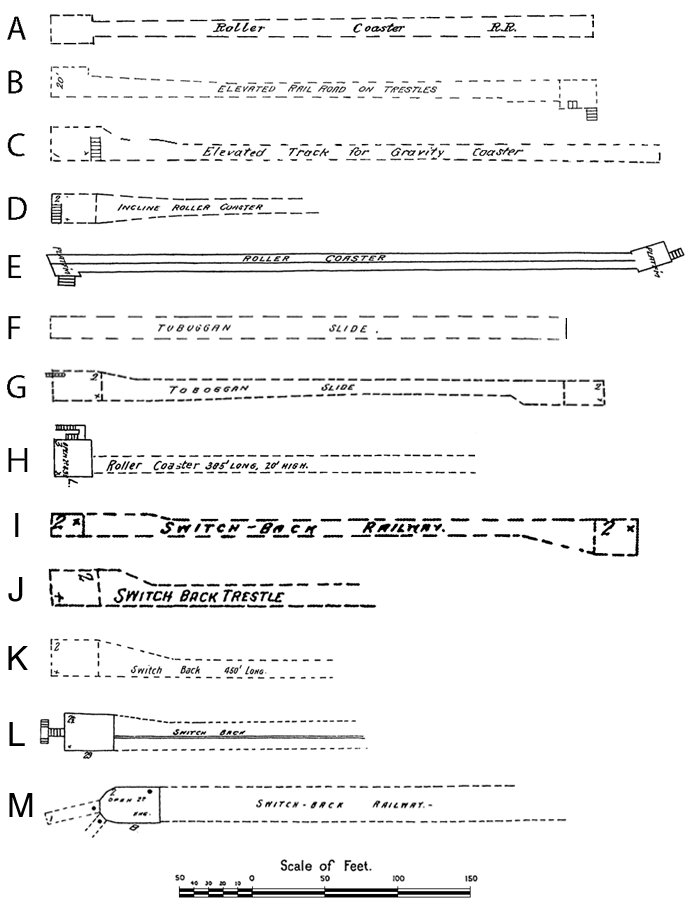
Linear coasters shown on Sanborn fire maps, with map dates.
A Atlantic City, New Jersey, 1886
B Philion's Little Coney Island, Paterson, New Jersey, 1887
C Central Park, San Francisco, California, 1887
D Reeds Lake, Grand Rapids, Michigan, 1888
E Arcadia Hotel, Santa Monica, California, 1888
F Asbury Park, New Jersey, 1890
G Highland Beach, New Jersey, 1890
H Cedar Point, Sandusky, Ohio, 1893
I Presque Isle, Toledo, Ohio, 1895
J Troost Park, Kansas City, Missouri, 1896
K Courtland Beach, Omaha, Nebraska, 1901
L Crocker Park, Des Moines, Iowa, 1901
M Euclid Beach, Cleveland, Ohio, 1903